Monday 29 April 2013

AL Gets a Tent :0)


I have finally bit the bullet and bought a tent for the trip.

I hummed and ha’ed for a while and did way to much research. I think I was becoming a bit os a bore if the trip came up in conversation and I would launch in to stats on different types of tents.
I read a lot of reviews and quickly came to the conclusion that when a manufacturer says a lightweight test is for 2 people then it will be snug for one person. So I started looking at lightweight 2 man tents.
I slowly (very slowly) narrowed it down to the following two
Vango Banshee 200  (£87 on Amazon)
 Coleman Cobra 2 (£69 on Amazon)


Then I saw the light…. The Coleman was cheaper and larger inside. Problem solved.

So I had a look on Ebay and would you believe it someone was selling a Coleman Cobra 3 (The three man version). Used once and still with Tags so I thought I would take a punt.

Well I won the bidding war (well not really a war, more of a last min bit) and got the tent for £75. Bargain as it should have been £120.

I put it up on Sunday and it was very quick and easy. Video below. It took 15 mins and it is a good size inside. Recon I will get the inflatable mattress in and all my kit. If there are problems then I am confident it can take the two of us and our kit.

Coleman Cobra 3


The tent is just short of 3Kg so it is nice and light
Only two problems….
       1.  When packed in its bag it is quite a lose bag. Will try and wrap it tighter to reduce its size.

       2. It stinks of Fish…. I have given it a VERY good wash and this appears to have removed the smell but will see when it dries out and I put it up again. I think it may have been put away wet or maybe the last owner used it once on a fishing trip.

Here is the video of me putting the tent up.


AL

AL Training ride 27th April 2013. The Sea Take Two.


Well it has been an expensive few weeks for the bike. Day after cleaning my bike (See my last blog entry) I started on my morning cycle and the chain snapped. Bobby did tell me that this was going to be expensive but I thought “Hey a chain can’t be that expensive… Can it?”. Well I got a new chain (and link tool) for £20 and thought that was not too bad. But after fitting the chain (Sheldon knows his stuff LINK) I went for a quick peddle. Didn't make it to the top of the street. The chain kept slipping around the front chain set. So I took it off and went to Edinburgh Bikes LINK where the chap told me it would defiantly be the rear free wheel…. that was until he saw the chain set to which he said “Ah that’s B*****d” and I picked up a new front chain set. But sure enough after fitting the new chain set I soon discovered that the freewheel needed replacing too. I use a MegaRange freewheel and I chose to get one the same of ebay so I had at least a week to wait so I fitted a spare standard freewheel to keep me going.
I also splashed out on some new cycle glasses. £5.50 from China. They do the job though :0)
So all in all it has been an expensive time as Bobby had warned me. Smart guy you know :0)

Training has been going well. I am now trying to do 10 miles each morning of the week before work and then a longer cycle at the weekend.
The morning cycles are usually around the local area and I am trying to vary them so that I don’t get too bored of the same old scenery every day. I am trying to keep the idea of hills to the fore and all routes have at least two assents on them.

This weekend’s route was a second attempt at reaching the sea. Difference with this trip is I was aiming for something’s big enough that I can see them from home. I headed for the Forth bridges (Road and Rail).

Zoomed in pic of Forth Road Bridge 15 miles away.
I looked at the forecast for Saturday and Sunday and decided on the Saturday Morning. This was because the wind would be against me on the way down to the bridges and on my back on the way back up the hills to home. The chance of rain was marginal but I recon we need to be used to it if we are intending on cycling in Scotland ;0)

On the Friday Night I decided to fit my front pannier racks (at last!). I need to get used to having extra weight on the front. The fitting did not go to plan. The “U” bolts supplied were not wide enough to fit round my extra thick front forks. Admittedly I was aware that this was likely to be a problem as a lot of people have mentioned this when reviewing the various different types of front pannier racks. So I set about widening the “U” bolts and fitting the racks on. One issue was that the position of the racks forced me to move my cycle computer sensor up the forks as the “U” bolts were destined to fit in the same place.

New Front Pannier Racks


 Well once the racks were fitted I moved some of the training weights from my rear panniers in to my new(ish) from panniers. I was very lucky to get the same type and colour of panniers for the front 15 years after getting the rear panniers :0). So now I have 10Kg in the rear and 5Kg in the front panniers. I also have a handle bar pannier that I have my food and drinks etc in.
I also found a perfect material to make a new spray guard from my mudguard  Its made from an old chewed up traffic cone I found. Works a treat. :0)

Home make Spray guard. Made from Traffic cone.


Well at 8am on the Saturday morning I set off for the Forth Road Bridge. Weather turned out to be great. 20mph wind from the north but lovely and sunny. Bridges are due North of me so in to wind the whole way there :0(
Quickly noticed that my cycle computer was not working. (Turned out to be the magnet was too far from the sensor now. Fixed it the next day)
This time I had printed off maps of the route so I would not get lost. I travelled down through Ratho to the Airport where I had to cross a dual carriage way on a foot bridge. Had to dismount for this as the steps were quite high and with all the extra weight I could not hop up them.

Plane on Edinburgh Airport runway

Tops of Forth Rode Bridge in the distance


Next it was along to the Newbridge roundabout where I joined the old railway route that would take me all the way to South Queensferry and the Forth Road Bridge. The old railway path was a bit boggy in places but good most of the way. Oddly it was a gentle uphill for about 8 miles on the old railway which I had not expected and with the head wind it was a bit of a chore.

Got to love the straight railways :0)


Once in to South Queensferry it was back on to the roads and along to the bridge. The views from the bridge were fantastic.

Forth Rail Bridge from car park

Forth Road Bridge from Carpark

Made it!!!!

The Forth Rail Bridge

South Queensferry

My trusty stead

Its a LONG bridge, this is half way over.

Train on the bridge


I cycled right over the bridge and then back to south Queensferry. I wanted to go down to the chandlery shop beneath the road bridge to pick up some boat bits. Then I cycled along to the old harbour in South Queensferry and had my hot chocolate and banana (and a couple of chocolate Biscuits) where it was out of the wind but lovely and warm.

Relaxing at the beach with the bridges behind.


 I met a couple of blokes who are painter decorators by trade but do some creel fishing in their spare time. They were saying since the work on the new bridge has started there catches are down due to the mucky water being created by the work. They also gave me some ideas for other routes along the coast :0)
Once I had finished my snack I started back home along the old railway again. The sun was still shining but this time the wind was on my back, but I have to be honest that my legs were beginning to ache, I think the 52 miles over the previous 5 days were taking their toll, but I must get used to it.

Last view of the rail bridge as I was leaving


Got back to the airport where I had a break for 5 mins to take a picture of the planes going over head.

They really were close!!!


After this it was back to the serious uphill climb to home. About 8 miles of it. And the hill back in to Balerno (we call it the railway hill) is very steep and about half a mile. But I was really please that I managed it all without getting off once.

Well that’s it for this weekend’s cycle training. Will keep up the daily 10 milers and see what I can think of for next weekend.

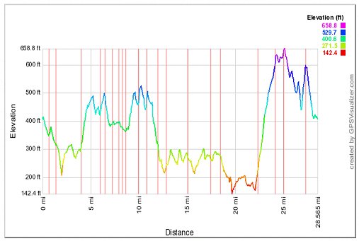
STATS (Bit of guess work here as the cycle computer was not working)
Distance:             30 miles according to Google maps
Average speed:   Approx. 10mph
Total time:          4.5 hours (but there was some shopping in there ;0))
Extra Weight:     20Kg
Wine Gum count: 4

AL

Sunday 21 April 2013

The Tortoise and the Hare

The Tortoise and the Hare.

The journey today did not start from when Gary and myself left Town Gate in Great Harwood at 08:05. Today’s journey really began when we crossed over into Preston and started riding on the lovely flat cycle paths. You could that this area was a better class but then we both inhaled somebody else’s fix (not nicotine) as we enjoyed the view from the Penwortham bridge, we both smiled and laughed. What had started out as simple journey ended up being one big adventure. Me the tortoise and Gary the hare. Gary got us both lost which in itself became a humbling experience as we cycled through the crematorium grounds in Preston. Saccary Lane ended up becoming Scary lane as I asked a bearded man coming down the hill with a pint of milk in his hand and a rucksack on his back if he had seen a cyclist, his response was to advise I am a snail too (I must add at this point I was not riding but pushing my bike up the hill). One thing you can credit Gary with was his reaction speed he missed falling down a pot hall which was the size of the Grand Canyon, I am just grateful that he was in front. We did eventually find our way home and parted company at the Spice Lounge. Overall what an experience reminded me of a younger me driving a little yellow van, a new friend found what a day.

I now feel the journey to the sea is now just a journey to far. You win Mr T.

A few stats on the journey 47miles, 9.4avg, 38.9max.
No maps (we got lost).

A few of my pictures taken at the Penwortham bridge to be added to the gallery.


Friday 12 April 2013

Follow the river and you will find the sea?

The Route following the River Ribble

Well Mr T’s throwing down yet another gauntlet please see his last post which starts “Well the aim of the ride today was to reach the sea. Recon that will be a challenge for Bobby to replicate ;0)”

What did we ever do before Google maps?

It does at first seem a journey to far, but then if I get to the sea I will see one of these …

Mr T will not see one of these?  ;-)

I have routed the first part of the journey as follows ..

Home -> Spice Lounge (via Rishton or Blackburn Old Rd  -> Ramsgreave -> Mellor -> Osbaldeston -> Balderstone -> Cycle route (*as per the map on the Lancashire County Council site) around the bottom of Preston and  finishing at the Penwortham bridge.

For the second part of the journey you continue onto Lytham St Anne’s.

The complete journey looks something like this …


OUT


BACK


A complete journey of 56 miles on mainly flat roads, it could be done?

Whilst I have other commitments this weekend I will hopefully attempt the first part of the journey next Sunday (21st April) with Gary. I will then hopeful go for the full journey on the 28th April, I could get to the sea before Mr T?

*  http://www.lancashire.gov.uk/corporate/web/?siteid=3732&pageid=28100&e=e


Monday 8 April 2013

Bob 7 Training “Test the rig (Part 2)”

Test the rig (Part 2)

Sunday the 7th April brought a lovely sunny morning, another opportunity to take the Dawes down the Ribble Valley.


Looks better with it’s back mudguard back on?


Karrimor Handle bar bag 2.5kg
The top dry bag contains my tent: Vango Tempest 200 3kg
(Transporting the tent in this fashion should ensure that it’s the first thing off the bike and the last thing on it).
The Karrimor Rack Pack below contains will contain two sleeping mats (lesson learnt from last year, total thickness both matts equals 2 3/4 inches) and a tent carpet, picnic rug for added insulation. 3kg
Avenir Pannier (left)  contains my kitchen. 5kg
Avenir Pannier (right)  contains my tools and waterproofs. 4kg

Total weight this journey 17.5kg.

Journey details ..
Home -> Whalley - > Wiswell > Pendleton -> Worston ->Downham ->  Chatburn -> West Bradford ->  Waddington -> Bashall Barn ->    Gt Mitton ->  Whalley -> York -> Home


Stats for the journey are as follows ...

Distance .. my computer advised  28.5 miles.

Max height : 658ft
Min height :  142ft

Max speed :   26 mph
Average :      9.7

Time 2hr 45min   
 

Sunday 7 April 2013

Al Training ride 06 April 2013


Well the aim of the ride today was to reach the sea. Recon that will be a challenge for Bobby to replicate ;0)
I looked on Google maps to see what was the quickest route to the coast (the firth of Forth), great its 15 miles… Perfect thought I. Route to the Sea
Looked at the map and reckoned it would be a great cycle to the coast and once there I can take a pics for the blog and then uphill all the way back. Grind….
I decided to add a wee bit more weight today. Upped it to 18Kg. Recon this will be fairly close to what I will be carrying in Skye but I will have to do as Bobby has and weight out the kit to be sure.

I set off and wend down to the Union Canal, an old favourite from last year’s canal path training.
View along the Union canal
 The cycle along the tow path would be bliss, the wind behind me and on the flat…. BUT…. I had forgotten about the pedestrians and there dogs, prams, children, etc. I was ruining the bell and saying “Thank you” a lot. I always feel saying “Thank you” to the people you pass is a good move and some have told me it is refreshing to have it said.

Its a busy place


Once in town I turned off the tow path and on to the city roads. As I was passing Tynecastle football stadium (home of Hearts) I hear the biggest roar I have heard in many a year (The won 3-1 I believe).

City cycling. This is where I heard the roar


I then wound my way down to the Roseburn Path near the Murryfield stadium. Murryfield stadium is where Bobby and I finished out Glasgow to Edinburgh ride a few years ago.

View back to Murryfiled


The paths through Edinburgh run along the old railway network and are great. Also my route was generally downhill. I got to the 15 mile mark and had not come to the sea but to the very nice Victoria Park…. Where did I go wrong? There had been a fork in the path a few miles back that I had taken but decided it was the wrong way and doubled back to this route. I realised I had got it wrong. Darn it. I could smell the sea but I had a fixed time to be home by so I stopped for a drink of Hot chocolate. Actual Route

The ride back felt a lot longer as it was a constant uphill until I made it back to the tow path but then I was head to the wind so it felt just the same. I kept plugging away and kept the average speed up.
The canal had some lovely sites and I did stop a few times to take pics.


Stats
Distance: 32 Miles
Cycling Time: 2hr 39mins
Total Time: 3hrs 10mins
Average Speed: 11.7mph
Max Speed: 26.6mph
Extra Weight: 18Kg
Wine Gums: 5 (yum yum in my tum)

The maps are split to reflect the slightly different return route I took as I had run out of time.


scrub a dub dub....
On the 7th April I did some bike maintenance and my wife took this pic of me cleaning the rear wheel. I went on to adjust the front breaks, replace the rear brakes, remove and clean the rear freewheel then clean and re-oil the chain. It was all needed as it had been about a month since the last maintenance session but at least this time it could be done in the sun.


Bobby and I have also agreed the route for the cycle and I have added it to the home page of the blog.
Also Bobby has arranged for us to support the Neaves Fund charity this year. I have also added that to the home page with the donate link.
Also I have moved some of the posts on to separate pages on the blog to make them easier to find.

Well that it for now.

Al

Down a man


News Update…. Unfortunately Andy will not be able to come along on the Skye ride due to “unforeseen circumstances”. We will really miss having Andy there. Andy was a great guy on the 2012 cycle. That man ate the biggest plate of meat in one sitting that I have ever seen and all washed down with a few pints.
Will miss you mate.

Al

Friday 5 April 2013

Bob 6 Training “Test the rig & climb that hill”.

Test the rig

Wednesday the 3rd April was a lovely day I spent the morning servicing the Dawes and then testing the rig in the afternoon with a short spin down the Ribble Valley.

The top dry bag contains my tent: Vango Tempest 200 3kg
(Transporting the tent in this fashion should ensure that it’s the first thing off the bike and the last thing on it).
The Karrimor Rack Pack below will contain two sleeping mats (lesson learnt from last year, total thickness both matts equals 2inches approx) and a tent carpet, picnic rug for added insulation. 3kg
Avenir Pannier (left)  contains my kitchen. 4.5kg
Avenir Pannier (right)  contains my tools and waterproofs. 4kg

Total weight this journey 14.5kg.

I left home and did one of my regular runs and just enjoyed the journey, I finally found myself in Downham at which point I parked myself for a rest and a brew.


Stats for the journey are as follows ...

Distance .. my computer advised  20.5 miles.


Max height : 524.6ft
Min height :  206.7ft

Max speed :   28 mph
Average :      10.5

Time 1hr 56min   

Climb that Hill

With the majority of my training routes running around the foot Pendle hill I thought it was about time to see the view from the top. On Thursday the 4th April my Father, my daughter Lilly and one of her friends made the trip to the top.

It was a bright sunny day at the foot of the hill by the time we made it to the top there was a very strong freezing easterly wind, the sun was still shining but it was very, very cold.

A few photos below of this trip …


The road to the top.

Brian, Robert & Meg (the dog) half way to the top.
Not a bad view ?

Proof that we did all make it !